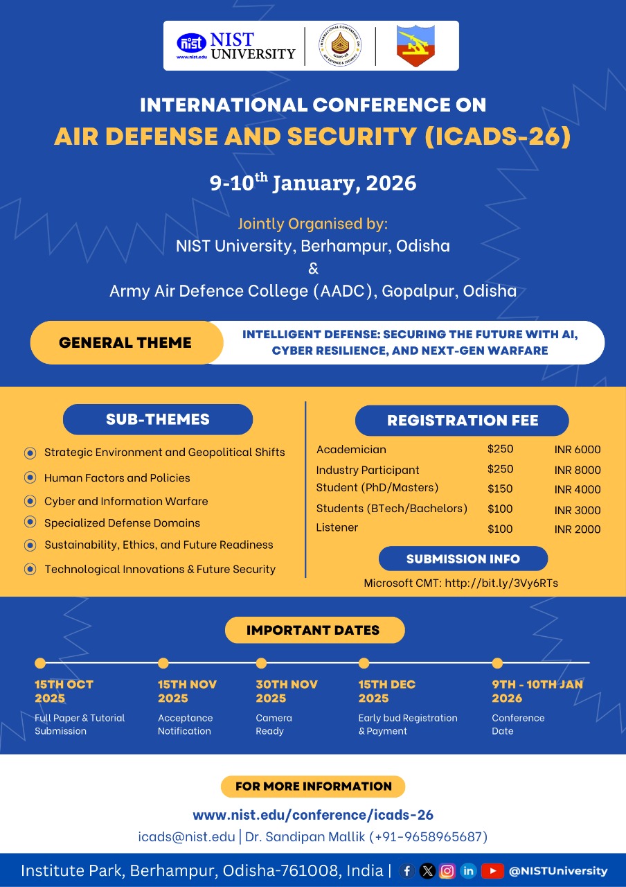
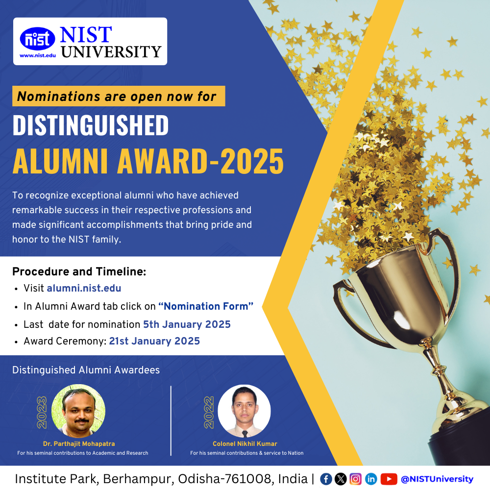
-
Samal, P., Swain, P.C. and Samantaray, S., 2025. Flood analysis using HEC-RAS 1D model for the delta of Brahmani river, Odisha, India. Natural Hazards, 121(7), pp.7941-7966.
-
Samal, P., Patnaik, P., Samantaray, S. and Swain, P.C., 2024. Comparative study of reservoir operations using TLBO, PSO and DE optimization techniques: an experiment on the Hirakud reservoir, Odisha, India. Journal of Water and Climate Change, 15(10), pp.5309-5331.
-
Samal, P., Swain, P.C. and Samantaray, S., 2024. GIS-based RUSLE model for estimating soil erosion and sediment yield in Rushikulya River Basin of Odisha, India. Journal of Earth System Science, 133(4), p.242.
-
Samal, P., Swain, P.C. and Samantaray, S., 2025. Assessment of runoff using GIS based SCS-CN approach on Badanadi sub watershed of Rushikulya basin. Proceedings of the Indian National Science Academy, pp.1-25.
-
P Samal, S Samantaray, PC Swain, HS Shakir, ZM Yaseen (2026) A Comparative Study of Developed Rainfall Intensity-Duration-Frequency Curves for Ganjam District, Odisha, India
Physics and Chemistry of the Earth, Parts A/B/C, 104284
-
P.Samal and P.C. Swain (2024)“Water quality assessment using parameters of Water Quality Index( WQI ) and mapping through GIS for River Rushikulya . International conference in River Corridor Research and Management 7th March 9th March 2024 IITG
-
P Samal,P. C. Swain, L. Mohanty “Flow Simulation in Brahmani and Mahanadi River Basin Using SWAT Model.” 30th Hydro (2025), International conference, NIT Rourkela, 18-20 December, Theme Hydroinformative and Smat water Mangement, Paper ID -235,
-
P.Samal and P.C. Swain (2023) Study of Land Use Land Cover (Lulc) Change Pattern in Both Mahanadi And Brahmani River Basin Using Gis Model. International Conference Climate Change, Disaster Resilience and Human Wellbeing(ICCCDRHW), 16-17 September, 2023 Organised by Centre of Excellence on Climate Change and Disaster Resilience(CECCDR), Berhampur University, Ganjam, Odisha
-
Samal and P. C. Swain, “Application of GIS based RUSLE model for estimating soil erosion and sediment yield in Rushikulya River Basin of Odisha, India” International Conference (virtual), Indian Society of Geomatics (ISG), Ranchi Chapter Vigyan Bharati Jharkhand International Society for Tropical Ecology (ISTE), ISG CUJ. Paper ID -2022/01P, pp 66-69, 2022.
-
P. Samal and P.C Swain,(2022)“Flood plain mapping using HEC-RAS A case study of Brahmani River” RDC-2022 MNNIT Allahbad.
-
P Samal and P. C. Swain, “Development of Rainfall Intensity-Duration-Frequency (IDF) curves of Ganjam District, Odisha, India.” 25th Hydro (2020), International conference, NIT Rourkela, 26-28 March, Theme XVIII Hydrometeorology, Paper ID -332, pp 254-267. ISBN : 978-93-90631-56-8, 2021
-
P.Samal, S.Rout, R. Choudhury, P.C.Swain (2026).HEC-RAS Modelling for River Basin Management of Indian Rivers—A Review Water Resour 53, 25–35


 (1)-Photoroom.png)